|
|
Antenna Structure Registration 1030877 |
 |
Registration Info | Registration Number: 1030877 |
| File Number: A1185268 |
| FAA Study: 2020-ASO-35460-OE |
| FAA Issue Date: 01/04/2021 |
| Status: Constructed |
| Date Constructed: 07/20/1992 |
| NEPA: N |
Structure Info
| Structure Type: GTOWER |
| Structure Coordinates: 30-13-57.7 N 82-48-17.1 W (NAD 83) |
| Structure Coordinates: 30-13-56.9 N 82-48-17.6 W (Converted to NAD 27) |
| Structure Address: Along Sr 250 1.4 Kme (fl24340-a) |
| Structure City: Wellborn, FL |
| Structure County: Suwannee County |
| Painting & Lighting Info |
FAA Circular #: 70/7460-1M |
FAA Chapters: 4, 8, 15 |
Remarks: PRIOR STUDY 1991-ASO-658-OE |
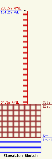
| Elevation Info |
Site Elevation: 54.3 meters (178 ft) |
| Height of Structure: 153 meters (502 feet) |
| Overall Height Above Ground: 154.2 meters (506 feet) |
| Overall Height Above Mean Sea Level: 208.5 meters (684 feet) |
| Owner Info | SBA Towers X, LLC
8051 Congress Avenue
Boca Raton, FL 33487
(561) 995-7670
ERoach@sbasite.com |
| Contact Info | SBA Towers X, LLC
8051 Congress Avenue
Boca Raton, FL 33487
(561) 995-7670
ERoach@sbasite.com |
