|
|
Antenna Structure Registration 1030897 |
 |
Registration Info | Registration Number: 1030897 |
| File Number: A0036599 |
| FAA Study: 97-AEA-2054-OE |
| FAA Issue Date: 09/11/1997 |
| Status: Constructed |
| Date Constructed: 05/01/1971 |
| NEPA: N |
Structure Info
| Structure Type: TOWER |
| Structure Coordinates: 40-19-3.0 N 75-38-59.0 W (NAD 83) |
| Structure Coordinates: 40-19-02.7 N 75-39-00.3 W (Converted to NAD 27) |
| Structure Address: 280 Mill St 1.3 Mi Ne |
| Structure City: Boyertown, PA |
| Structure County: Berks County |
| Painting & Lighting Info |
FAA Circular #: 70/7460-1J |
FAA Chapters: 3, 4, 5, 13 |
| Elevation Info |
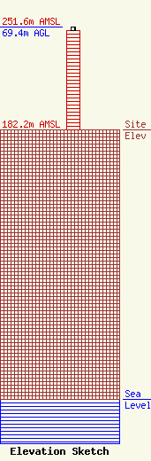
Site Elevation: 182.2 meters (598 ft) |
| Height of Structure: 67 meters (220 feet) |
| Overall Height Above Ground: 69.4 meters (228 feet) |
| Overall Height Above Mean Sea Level: 251.6 meters (825 feet) |
| Owner Info | WDAC RADIO COMPANY
3022
LANCASTER, PA 17604
(610) 369-7777
|
