|
|
Antenna Structure Registration 1030912 |
 |
Registration Info | Registration Number: 1030912 |
| File Number: A0978679 |
| FAA Study: 94-AGL-1245-OE |
| FAA Issue Date: 03/18/1994 |
| Status: Constructed |
| Date Constructed: 01/01/2015 |
| NEPA: N |
Structure Info
| Structure Type: GTOWER |
| Structure Coordinates: 40-9-19.0 N 85-25-48.0 W (NAD 83) |
| Structure Coordinates: 40-09-18.8 N 85-25-48.1 W (Converted to NAD 27) |
| Structure Address: 3805 W. White Road |
| Structure City: Muncie, IN |
| Structure County: Delaware County |
| Painting & Lighting Info |
FAA Circular #: 70/7460-1H |
FAA Chapters: 3, 13 |
| Elevation Info |
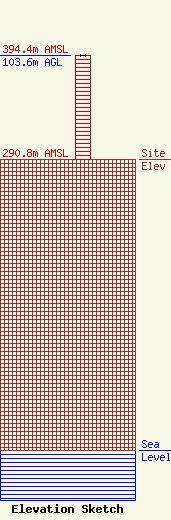
Site Elevation: 290.8 meters (954 ft) |
| Height of Structure: 103.6 meters (340 feet) |
| Overall Height Above Ground: 103.6 meters (340 feet) |
| Overall Height Above Mean Sea Level: 394.4 meters (1294 feet) |
| Owner Info | Woof Boom Radio Muncie License LLC
800 East 29th Street
Muncie, IN 47302
(765) 288-4403
j.chapman@woofboom.com |
| Contact Info | Woof Boom Radio Muncie License LLC
800 East 29th Street
Muncie, IN 47302
(765) 288-4403
sean.mattingly@woofboom.com |
