|
|
Antenna Structure Registration 1031222 |
 |
Registration Info | Registration Number: 1031222 |
| File Number: A0731251 |
| FAA Study: 2011-ACE-1139-OE |
| FAA Issue Date: 04/25/2011 |
| Status: Constructed |
| Date Constructed: 06/29/2011 |
| FAA EMI: N |
| NEPA: N |
Structure Info
| Structure Type: TOWER |
| Structure Coordinates: 38-47-6.0 N 100-55-15.0 W (NAD 83) |
| Structure Coordinates: 38-47-06.0 N 100-55-13.5 W (Converted to NAD 27) |
| Structure Address: .8 Km South And 5.4 Km West Of Elkader |
| Structure City: Russell Springs, KS |
| Structure County: Logan County |
| Painting & Lighting Info |
FAA Circular #: 70/7460-1H |
FAA Chapters: 4, 6, 13 |
Remarks: PRIOR STUDY 2008-ACE-971-OE |
Remarks: OM&L to remain the same as prior study = 24-HR MED-STROBES |
Remarks: PRIOR STUDY 2008-ACE-971-OE |
Remarks: OM&L to remain the same as prior study = 24-HR MED-STROBES |
| Elevation Info |
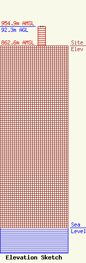
Site Elevation: 862.6 meters (2830 ft) |
| Height of Structure: 92.3 meters (303 feet) |
| Overall Height Above Ground: 92.3 meters (303 feet) |
| Overall Height Above Mean Sea Level: 954.9 meters (3133 feet) |
| Owner Info | Sunflower Electric Power Corporation
301 West 13th street
1020
Hays, KS 67601
(785) 628-2845
jgeil@sunflower.net |
| Contact Info | Sunflower Electric Power Corporation
301 West 13th street
1020
Hays, KS 67601
John Geil
(785) 628-2845
jgeil@sunflower.net |
