|
|
Antenna Structure Registration 1031895 |
 |
Registration Info | Registration Number: 1031895 |
| File Number: A1297341 |
| FAA Study: 97-ACE-1029-OE |
| FAA Issue Date: 08/25/1997 |
| Status: Constructed |
| Date Constructed: 01/01/1965 |
| FAA EMI: N |
| NEPA: N |
Structure Info
| Structure Type: TOWER |
| Structure Coordinates: 39-14-8.0 N 101-6-59.0 W (NAD 83) |
| Structure Coordinates: 39-14-08.0 N 101-06-57.4 W (Converted to NAD 27) |
| Structure Address: 11.0 Mi. South And 3 Mi. West |
| Structure City: Colby, KS |
| Structure County: Thomas County |
| Painting & Lighting Info |
FAA Circular #: 70/7460-1J |
FAA Chapters: 3, 4, 5, 13 |
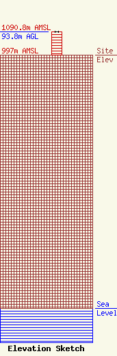
| Elevation Info |
Site Elevation: 997 meters (3271 ft) |
| Height of Structure: 92.8 meters (304 feet) |
| Overall Height Above Ground: 93.8 meters (308 feet) |
| Overall Height Above Mean Sea Level: 1090.8 meters (3579 feet) |
| Owner Info | Gray Local Media, Inc.
4370 Peachtree Road, NE
Atlanta, GA 30319
(404) 266-8333
legalnotices@graymedia.com |
| Contact Info | Gray Local Media, Inc.
4370 Peachtree Road NE
Atlanta, GA 30319
Engineering Department
(404) 266-8333
legalnotices@graymedia.com |
