|
|
Antenna Structure Registration 1032380 |
 |
Registration Info | Registration Number: 1032380 |
| File Number: A1328153 |
| Status: Constructed |
| Date Constructed: 01/01/1972 |
| NEPA: N |
Structure Info
|
| Structure Coordinates: 48-40-49.0 N 122-50-31.0 W (NAD 83) |
| Structure Coordinates: 48-40-49.6 N 122-50-26.3 W (Converted to NAD 27) |
| Structure Address: Approx 1/2 Mile West Of Summit Mt Constitution, Orcas Is. |
| Structure City: Eastsound, WA |
| Structure County: San Juan County |
| Painting & Lighting Info |
FCC Paragraph(s): 1, 3, 12, 21 |
| Elevation Info |
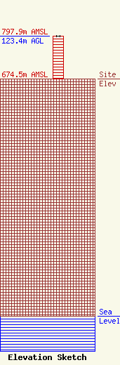
Site Elevation: 674.5 meters (2213 ft) |
| Height of Structure: 121.9 meters (400 feet) |
| Overall Height Above Ground: 123.4 meters (405 feet) |
| Overall Height Above Mean Sea Level: 797.9 meters (2618 feet) |
| Owner Info | K2 Towers III, LLC
57 E Washington Street
Chagrin Falls, OH 44022
(440) 528-0333
rlepene@k2towers.com |
| Contact Info | K2 Towers III, LLC
57 E Washington Street
Chagrin Falls, OH 44022
Greg Thompson
(440) 528-0333
gthompson@k2towers.com |
