|
|
Antenna Structure Registration 1032389 |
 |
Registration Info | Registration Number: 1032389 |
| File Number: A0843076 |
| FAA Study: 2013-ANM-922-OE |
| FAA Issue Date: 06/25/2013 |
| Status: Constructed |
| Date Constructed: 01/01/1970 |
| FAA EMI: N |
| NEPA: N |
Structure Info
| Structure Type: GTOWER |
| Structure Coordinates: 46-31-56.4 N 120-30-46.5 W (NAD 83) |
| Structure Coordinates: 46-31-56.9 N 120-30-42.3 W (Converted to NAD 27) |
| Structure Address: Ahtanum Ridge 2 Mi S |
| Structure City: Yakima, WA |
| Structure County: Yakima County |
| Painting & Lighting Info |
FAA Circular #: 70/7460-1K |
FAA Chapters: 3, 4, 5, 12 |
Remarks: OM&L to remain the same as prior studies = PAINT/RED LIGHTS |
Remarks: PRIOR STUDIES 2007-ANM-2202-OE / 2004-ANM-1707-OE |
Remarks: OM&L to remain the same as prior studies = PAINT/RED LIGHTS |
Remarks: PRIOR STUDIES 2007-ANM-2202-OE / 2004-ANM-1707-OE |
| Elevation Info |
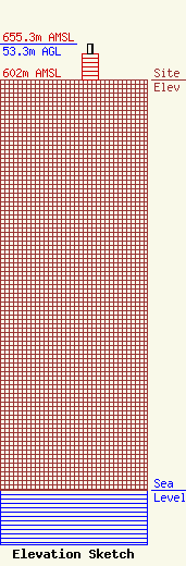
Site Elevation: 602 meters (1975 ft) |
| Height of Structure: 38.1 meters (125 feet) |
| Overall Height Above Ground: 53.3 meters (175 feet) |
| Overall Height Above Mean Sea Level: 655.3 meters (2150 feet) |
| Owner Info | APPLE VALLEY BROADCASTING INC DBA = KAPP TV
601 N EDISON
KENNEWICK, WA 99336
(509) 453-0351
NEILB@KVEWTV.COM |
| Contact Info | Hatfield & Dawson Consulting Engineers
9500 Greenwood Ave N
Seattle, WA 98103
Erik Swanson
(206) 783-9151
eswanson@hatdaw.com |
