|
|
Antenna Structure Registration 1032600 |
 |
Registration Info | Registration Number: 1032600 |
| File Number: A1063840 |
| FAA Study: 89-ANM-0022-OE |
| FAA Issue Date: 01/01/1989 |
| Status: Constructed |
| Date Constructed: 12/01/1955 |
| FAA EMI: N |
| NEPA: N |
Structure Info
|
| Structure Coordinates: 46-27-27.0 N 117-6-0.0 W (NAD 83) |
| Structure Coordinates: 46-27-27.4 N 117-05-56.4 W (Converted to NAD 27) |
| Structure Address: 2.5 Mi Sw Of Us 195 3 Mi Nw |
| Structure City: Clarkston, WA |
| Structure County: Whitman County |
| Painting & Lighting Info |
FAA Circular #: 70/7460-1G |
FAA Chapters: 3, 4, 5, 9 |
Remarks: RED LIGHTS/PAINT |
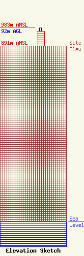
| Elevation Info |
Site Elevation: 891 meters (2923 ft) |
| Height of Structure: 76 meters (249 feet) |
| Overall Height Above Ground: 92 meters (302 feet) |
| Overall Height Above Mean Sea Level: 983 meters (3225 feet) |
| Owner Info | SINCLAIR LEWISTON LICENSEE, LLC
Pillsbury Winthrop Shaw Pittman LLP
Washington, DC 20036
(202) 663-8195
miles.mason@pillsburylaw.com |
| Contact Info | SINCLAIR LEWISTON LICENSEE, LLC
Pillsbury Winthrop Shaw Pittman LLP
Washington, DC 20036
(202) 663-8195
miles.mason@pillsburylaw.com |
