|
|
Antenna Structure Registration 1032644 |
 |
Registration Info | Registration Number: 1032644 |
| File Number: A0390722 |
| FAA Study: 97-ACE-1020-OE |
| FAA Issue Date: 08/25/1997 |
| Status: Constructed |
| Date Constructed: 04/30/2003 |
| FAA EMI: N |
| NEPA: N |
Structure Info
| Structure Type: TOWER |
| Structure Coordinates: 38-46-16.0 N 98-44-17.0 W (NAD 83) |
| Structure Coordinates: 38-46-16.0 N 98-44-15.7 W (Converted to NAD 27) |
| Structure Address: 8.8 Mi. Se Of |
| Structure City: Russell, KS |
| Structure County: Russell County |
| Painting & Lighting Info |
FAA Circular #: 70/7460-1J |
FAA Chapters: 4, 7, 13 |
| Elevation Info |
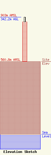
Site Elevation: 560.8 meters (1840 ft) |
| Height of Structure: 304.5 meters (999 feet) |
| Overall Height Above Ground: 342.2 meters (1123 feet) |
| Overall Height Above Mean Sea Level: 903 meters (2963 feet) |
| Owner Info | SMOKY HILLS PUBLIC TELEVISION, INC.
604 ELM STREET
9
BUNKER HILL, KS 67626
(785) 483-6990
lmintzmyer@shptv.org |
