|
|
Antenna Structure Registration 1032663 |
 |
Registration Info | Registration Number: 1032663 |
| File Number: A1070882 |
| FAA Study: 2008-AEA-2881-OE |
| FAA Issue Date: 07/02/2008 |
| Status: Dismantled |
| Date Constructed: 07/02/2008 |
| FAA EMI: N |
| NEPA: N |
Structure Info
|
| Structure Coordinates: 37-11-37.4 N 80-9-25.0 W (NAD 83) |
| Structure Coordinates: 37-11-36.9 N 80-09-25.9 W (Converted to NAD 27) |
| Structure Address: Poor Mountain Communications Site ( 310417 ) |
| Structure City: Bent Mountain, VA |
| Structure County: Roanoke County |
| Painting & Lighting Info |
FAA Circular #: 70/7460-1K |
FAA Chapters: 4, 8, 12 |
Remarks: PRIOR STUDY 2003-AEA-3518-OE |
| Elevation Info |
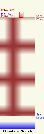
Site Elevation: 1146 meters (3760 ft) |
| Height of Structure: 61.8 meters (203 feet) |
| Overall Height Above Ground: 64 meters (210 feet) |
| Overall Height Above Mean Sea Level: 1210 meters (3970 feet) |
| Owner Info | SpectraSite Communications, LLC. through American Towers, LLC.
10 Presidential Way
Woburn, MA 01801
(678) 564-3236
faa-fcc@americantower.com |
| Contact Info | SpectraSite Communications, LLC. through American Towers, LLC.
10 Presidential Way
Woburn, MA 01801
(678) 564-3236
faa-fcc@americantower.com |
