|
|
Antenna Structure Registration 1033565 |
 |
Registration Info | Registration Number: 1033565 |
| File Number: A0736831 |
| FAA Study: 97-ACE-1820-OE |
| FAA Issue Date: 02/04/1998 |
| Status: Constructed |
| Date Constructed: 09/01/1984 |
| FAA EMI: N |
| NEPA: N |
Structure Info
| Structure Type: TOWER |
| Structure Coordinates: 38-54-23.0 N 98-51-40.0 W (NAD 83) |
| Structure Coordinates: 38-54-23.0 N 98-51-38.7 W (Converted to NAD 27) |
| Structure Address: 1984 N Main St |
| Structure City: Russell, KS |
| Structure County: Russell County |
| Painting & Lighting Info |
FAA Circular #: 70/7460-1J |
FAA Chapters: 3, 4, 5, 13 |
| Elevation Info |
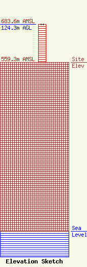
Site Elevation: 559.3 meters (1835 ft) |
| Height of Structure: 124.3 meters (408 feet) |
| Overall Height Above Ground: 124.3 meters (408 feet) |
| Overall Height Above Mean Sea Level: 683.6 meters (2243 feet) |
| Owner Info | White Communications, LLC
3011 West 84th Place
Leawood, KS 66026-1308
(913) 642-8255
fwhitesports@aol.com |
