|
|
Antenna Structure Registration 1033575 |
 |
Registration Info | Registration Number: 1033575 |
| File Number: A1206072 |
| FAA Study: 97-AWP-2228-OE |
| Status: Constructed |
| Date Constructed: 01/01/1994 |
| FAA EMI: N |
| NEPA: N |
Structure Info
| Structure Type: TOWER |
| Structure Coordinates: 37-43-44.0 N 121-7-38.0 W (NAD 83) |
| Structure Coordinates: 37-43-44.3 N 121-07-34.2 W (Converted to NAD 27) |
| Structure Address: 1220 S Acacia Ave |
| Structure City: Ripon, CA |
| Structure County: San Joaquin County |
| Painting & Lighting Info |
FAA Circular #: 70/7460-1H |
FAA Chapters: 4, 8, 13 |
| Elevation Info |
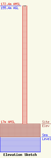
Site Elevation: 17 meters (56 ft) |
| Height of Structure: 155.4 meters (510 feet) |
| Overall Height Above Ground: 155.4 meters (510 feet) |
| Overall Height Above Mean Sea Level: 172.4 meters (566 feet) |
| Owner Info | Nextel West Corp.
12920 S.E. 38th Street
Bellevue, WA 98006
(425) 383-8401
FCCRegulatoryComplianceContact@t-mobile.com |
| Contact Info | Nextel West Corp.
12920 S.E. 38th Street
Bellevue, WA 98006
(425) 383-8401
FCCRegulatoryComplianceContact@t-mobile.com |
