|
|
Antenna Structure Registration 1033615 |
 |
Registration Info | Registration Number: 1033615 |
| File Number: A1213650 |
| FAA Study: 93-AEA-0728-OE |
| FAA Issue Date: 12/23/1993 |
| Status: Constructed |
| Date Constructed: 08/15/1993 |
| FAA EMI: N |
| NEPA: N |
Structure Info
|
| Structure Coordinates: 38-16-54.0 N 80-52-9.0 W (NAD 83) |
| Structure Coordinates: 38-16-53.6 N 80-52-09.6 W (Converted to NAD 27) |
| Structure Address: .9 Mi W Jct St Rt 39 & 41 |
| Structure City: Summersville, WV |
| Structure County: Nicholas County |
| Painting & Lighting Info |
FAA Circular #: 70/7460-1H |
FAA Chapters: 3, 4, 5, 13 |
Remarks: Removed expiration and final dates from determination. Scenario 2./jjs/case#635066 |
| Elevation Info |
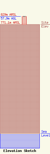
Site Elevation: 771.1 meters (2530 ft) |
| Height of Structure: 57.9 meters (190 feet) |
| Overall Height Above Ground: 57.9 meters (190 feet) |
| Overall Height Above Mean Sea Level: 829.1 meters (2720 feet) |
| Owner Info | LLoyd Hoff Holding Corp.
166 Jack Burlingame Dr.
Millwood, WV 25262
(130) 427-3279
support@lloydselectronics.com |
| Info |
