|
|
Antenna Structure Registration 1033712 |
 |
Registration Info | Registration Number: 1033712 |
| File Number: A1245632 |
| FAA Study: 2022-AGL-20462-OE |
| FAA Issue Date: 11/01/2022 |
| Status: Constructed |
| Date Constructed: 12/18/1998 |
| NEPA: N |
Structure Info
| Structure Type: LTOWER |
| Structure Coordinates: 43-2-49.0 N 87-58-52.0 W (NAD 83) |
| Structure Coordinates: 43-02-49.0 N 87-58-51.7 W (Converted to NAD 27) |
| Structure Address: 5407 West Mckinley Avenue |
| Structure City: Milwaukee, WI |
| Structure County: Milwaukee County |
| Painting & Lighting Info |
FAA Circular #: 70/7460-1M |
FAA Chapters: 4, 8, 15 |
Remarks: PRIOR STUDY 2007-AGL-7114-OE |
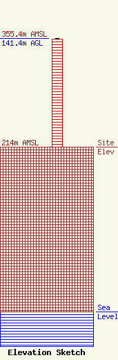
| Elevation Info |
Site Elevation: 214 meters (702 ft) |
| Height of Structure: 140.5 meters (461 feet) |
| Overall Height Above Ground: 141.4 meters (464 feet) |
| Overall Height Above Mean Sea Level: 355.4 meters (1166 feet) |
| Owner Info | Lakefront Communications, LLC
73 Kercheval Avenue
Grosse Pointe Farms, MI 48236
(313) 886-7070
fcclicenses@sagacom.com |
| Contact Info | Lakefront Communications, LLC
73 Kercheval Avenue
Grosse Pointe Farms, MI 48236
Tom Atkins
(313) 886-7070
fcclicenses@sagacom.com |
