|
|
Antenna Structure Registration 1033821 |
 |
Registration Info | Registration Number: 1033821 |
| File Number: A0776693 |
| FAA Study: MSP-68-83-OE |
| FAA Issue Date: 03/21/1969 |
| Status: Constructed |
| Date Constructed: 08/01/1970 |
| FAA EMI: N |
| NEPA: N |
Structure Info
| Structure Type: 4TA3 |
| Structure Coordinates: 44-51-26.0 N 89-35-16.0 W (NAD 83) |
| Structure Coordinates: 44-51-26.1 N 89-35-15.6 W (Converted to NAD 27) |
| Structure Address: Twr 3 - 3.3 Mi S Of Wi Hwy 29 On Cth X |
| Structure City: Rothschild, WI |
| Structure County: Marathon County |
| Painting & Lighting Info |
FCC Paragraph(s): 1, 3, 12, 21 |
Remarks: RED LIGHTS/PAINT |
| Elevation Info |
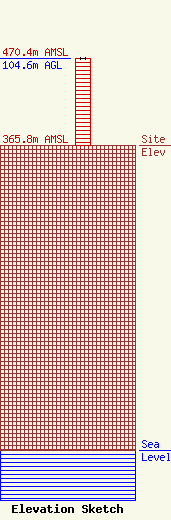
Site Elevation: 365.8 meters (1200 ft) |
| Height of Structure: 103.6 meters (340 feet) |
| Overall Height Above Ground: 104.6 meters (343 feet) |
| Overall Height Above Mean Sea Level: 470.4 meters (1543 feet) |
| Owner Info | WRIG INC
904 Grand Ave.
WAUSAU, WI 54403
(715) 842-1437
|
