|
|
Antenna Structure Registration 1034213 |
 |
Registration Info | Registration Number: 1034213 |
| File Number: A0975715 |
| FAA Study: 2015-ANM-1725-OE |
| FAA Issue Date: 07/07/2015 |
| Status: Constructed |
| Date Constructed: 07/26/2000 |
| NEPA: N |
Structure Info
| Structure Type: GTOWER |
| Structure Coordinates: 46-51-42.3 N 117-10-32.5 W (NAD 83) |
| Structure Coordinates: 46-51-42.7 N 117-10-28.9 W (Converted to NAD 27) |
| Structure Address: On Kamiak Butte 5.5 Sw |
| Structure City: Palouse, WA |
| Structure County: Whitman County |
| Painting & Lighting Info |
FAA Circular #: 70/7460-1K |
FAA Chapters: 3, 4, 5, 12 |
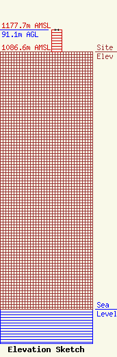
| Elevation Info |
Site Elevation: 1086.6 meters (3565 ft) |
| Height of Structure: 91 meters (299 feet) |
| Overall Height Above Ground: 91.1 meters (299 feet) |
| Overall Height Above Mean Sea Level: 1177.7 meters (3864 feet) |
| Owner Info | WASHINGTON STATE UNIVERSITY
382 Jackson Hall
642530
PULLMAN, WA 99164-2530
(509) 335-6536
blackerd@wsu.edu |
| Contact Info | Gray Miller Persh LLP
1200 New Hampshire Avenue NW, # 410
Washington, DC 20036
Barry Persh
(202) 776-2458
bpersh@graymillerpersh.com |
