|
|
Antenna Structure Registration 1034390 |
 |
Registration Info | Registration Number: 1034390 |
| File Number: A1194741 |
| FAA Study: 2015-AEA-4773-OE |
| FAA Issue Date: 09/03/2015 |
| Status: Constructed |
| Date Constructed: 01/19/2016 |
| NEPA: N |
Structure Info
| Structure Type: LTOWER |
| Structure Coordinates: 37-46-22.5 N 80-42-25.7 W (NAD 83) |
| Structure Coordinates: 37-46-22.1 N 80-42-26.4 W (Converted to NAD 27) |
| Structure Address: Top Of Keeney Knob |
| Structure City: Alderson, WV |
| Structure County: Summers County |
| Painting & Lighting Info |
FAA Circular #: 70/7460-1K |
FAA Chapters: 4, 8, 12 |
Remarks: PRIOR STUDY 2003-AEA-746-OE |
Remarks: OM&L to remain the same as prior study = A MED-DUAL SYSTEM |
Remarks: PRIOR STUDY 2003-AEA-746-OE |
Remarks: OM&L to remain the same as prior study = A MED-DUAL SYSTEM |
| Elevation Info |
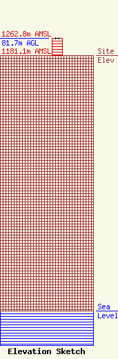
Site Elevation: 1181.1 meters (3875 ft) |
| Height of Structure: 80 meters (262 feet) |
| Overall Height Above Ground: 81.7 meters (268 feet) |
| Overall Height Above Mean Sea Level: 1262.8 meters (4143 feet) |
| Owner Info | Nexstar Media Inc.
545 E. John Carpenter Freeway
Irving, TX 75062
(972) 373-8800
jasroberts@nexstar.tv |
| Contact Info | Nexstar Media Inc.
545 E. John Carpenter Freeway
Irving, TX 75062
Jason Roberts
(972) 373-8800
jasroberts@nexstar.tv |
