|
|
Antenna Structure Registration 1034694 |
 |
Registration Info | Registration Number: 1034694 |
| File Number: A1191619 |
| FAA Study: 97-ANE-0169-OE |
| Status: Constructed |
| Date Constructed: 01/01/1967 |
| FAA EMI: N |
| NEPA: N |
Structure Info
| Structure Type: TOWER |
| Structure Coordinates: 43-2-0.0 N 72-22-2.0 W (NAD 83) |
| Structure Coordinates: 43-01-59.7 N 72-22-03.7 W (Converted to NAD 27) |
| Structure Address: On Derry Hill 8 Mi Nnw Of Keene Nh |
| Structure City: Walpole, NH |
| Structure County: Cheshire County |
| Painting & Lighting Info |
FCC Paragraph(s): 1, 3, 4, 13, 21 |
| Elevation Info |
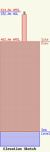
Site Elevation: 462.4 meters (1517 ft) |
| Height of Structure: 138.7 meters (455 feet) |
| Overall Height Above Ground: 152.4 meters (500 feet) |
| Overall Height Above Mean Sea Level: 614.8 meters (2017 feet) |
| Owner Info | New Hampshire Public Broadcasting
268 Mast Road
Durham, NH 03824
(603) 868-1100
schao@nhpbs.org |
| Contact Info | Foster Garvey P.C.
1000 Potomac St., NW
Washington, DC 20007
Brad Deutsch
(202) 298-1793
brad.deutsch@foster.com |
