|
|
Antenna Structure Registration 1034782 |
 |
Registration Info | Registration Number: 1034782 |
| File Number: A0998504 |
| FAA Study: 2013-AGL-4661-OE |
| FAA Issue Date: 06/19/2013 |
| Status: Constructed |
| Date Constructed: 10/01/1983 |
| FAA EMI: N |
| NEPA: N |
Structure Info
| Structure Type: GTOWER |
| Structure Coordinates: 44-21-30.0 N 87-58-48.4 W (NAD 83) |
| Structure Coordinates: 44-21-30.0 N 87-58-48.0 W (Converted to NAD 27) |
| Structure Address: 3329 Shirley Rd |
| Structure City: Glenmore, WI |
| Structure County: Brown County |
| Painting & Lighting Info |
FAA Circular #: 70/7460-1K |
FAA Chapters: 4, 7, 12 |
Remarks: PRIOR STUDY 2010-AGL-1884-OE |
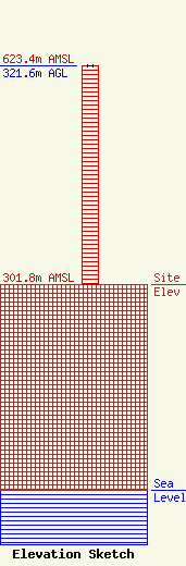
| Elevation Info |
Site Elevation: 301.8 meters (990 ft) |
| Height of Structure: 320.6 meters (1052 feet) |
| Overall Height Above Ground: 321.6 meters (1055 feet) |
| Overall Height Above Mean Sea Level: 623.4 meters (2045 feet) |
| Owner Info | Scripps Broadcasting Holdings LLC
312 Walnut Street
Cincinnati, OH 45202
(513) 977-3000
dave.giles@scripps.com |
| Contact Info | Baker & Hostetler LLP
1050 Connecticut Ave., NW
Washington, DC 20036
Kenneth Howard
(202) 861-1580
khoward@bakerlaw.com |
