|
|
Antenna Structure Registration 1034845 |
 |
Registration Info | Registration Number: 1034845 |
| File Number: A0353119 |
| FAA Study: 00-ACE-1907-OE |
| FAA Issue Date: 10/13/2000 |
| Status: Constructed |
| Date Constructed: 01/01/1997 |
| FAA EMI: N |
| NEPA: N |
Structure Info
| Structure Type: TOWER |
| Structure Coordinates: 38-59-39.7 N 95-42-6.9 W (NAD 83) |
| Structure Coordinates: 38-59-39.7 N 95-42-06.0 W (Converted to NAD 27) |
| Structure Address: 4100 Southgate Dr |
| Structure City: Topeka, KS |
| Structure County: Shawnee County |
| Painting & Lighting Info |
FAA Circular #: 70/7460-1K |
FAA Chapters: 3, 4, 5, 12 |
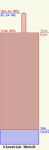
| Elevation Info |
Site Elevation: 303 meters (994 ft) |
| Height of Structure: 60.3 meters (198 feet) |
| Overall Height Above Ground: 61.1 meters (200 feet) |
| Overall Height Above Mean Sea Level: 364.1 meters (1195 feet) |
| Owner Info | Montgomery Communications, Inc.
222 West Sixth Street
Junction city, KS 66441
(785) 762-5000
dave@fox43topeka.com |
| Contact Info | Montgomery Communications, Inc.
222 West Sixth Street
Junction City, KS 66441
John Montgomery
(785) 762-5000
|
