|
|
Antenna Structure Registration 1035124 |
 |
Registration Info | Registration Number: 1035124 |
| File Number: A0041534 |
| FAA Study: 77-AEA-413-OE |
| FAA Issue Date: 05/01/1977 |
| Status: Constructed |
| Date Constructed: 10/01/1981 |
| NEPA: N |
Structure Info
| Structure Type: TOWER |
| Structure Coordinates: 40-12-58.0 N 80-33-30.0 W (NAD 83) |
| Structure Coordinates: 40-12-57.7 N 80-33-30.7 W (Converted to NAD 27) |
| Structure Address: Wv St Rt 88 1.7 Km Ne Int Rts 88 & 67 |
| Structure City: Bethany, WV |
| Structure County: Brooke County |
| Painting & Lighting Info |
FCC Paragraph(s): 1, 3, 12, 21 |
Remarks: RED LIGHTS/PAINT |
| Elevation Info |
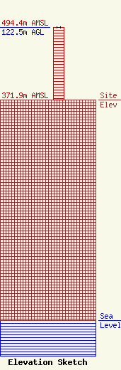
Site Elevation: 371.9 meters (1220 ft) |
| Height of Structure: 121.6 meters (399 feet) |
| Overall Height Above Ground: 122.5 meters (402 feet) |
| Overall Height Above Mean Sea Level: 494.4 meters (1622 feet) |
| Owner Info | WEST VIRGINIA EDUCATIONAL BROADCASTING AUTHORITY
600 CAPITOL DR
CHARLESTON, WV 25301-1223
(304) 558-3400
RITA_RAY@WSWP.PBS.ORG |
