|
|
Antenna Structure Registration 1035131 |
 |
Registration Info | Registration Number: 1035131 |
| File Number: A0675275 |
| FAA Study: 2009-AEA-3289-OE |
| FAA Issue Date: 11/24/2009 |
| Status: Constructed |
| Date Constructed: 02/08/2010 |
| FAA EMI: N |
| NEPA: N |
Structure Info
| Structure Type: TOWER |
| Structure Coordinates: 37-53-46.4 N 80-59-20.3 W (NAD 83) |
| Structure Coordinates: 37-53-46.0 N 80-59-21.0 W (Converted to NAD 27) |
| Structure Address: State Route 41/12, 4 Miles Sw Of Layland |
| Structure City: Layland, WV |
| Structure County: Fayette County |
| Painting & Lighting Info |
FAA Circular #: 70/7460-1K |
FAA Chapters: 4, 8, 12 |
Remarks: PRIOR STUDY 2002-AEA-2105-OE |
Remarks: Removed expiration date from determination. Scenario 1./jjs/case#635066 |
Remarks: PRIOR STUDY 2002-AEA-2105-OE |
Remarks: Removed expiration date from determination. Scenario 1./jjs/case#635066 |
| Elevation Info |
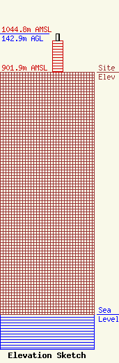
Site Elevation: 901.9 meters (2959 ft) |
| Height of Structure: 115 meters (377 feet) |
| Overall Height Above Ground: 142.9 meters (469 feet) |
| Overall Height Above Mean Sea Level: 1044.8 meters (3428 feet) |
| Owner Info | West Virginia Educational Broadcasting Authority
600 Capitol Street
Charleston, WV 25301
(304) 556-4900
dadkins@wvpubcast.org |
| Contact Info | West Virginia Public Broadcasting
9004
Beckley, WV 25802-9004
Jeremy Scott
(304) 254-7840
jscott@wvpubcast.org |
