|
|
Antenna Structure Registration 1035140 |
 |
Registration Info | Registration Number: 1035140 |
| File Number: A0353386 |
| Status: Constructed |
| Date Constructed: 01/01/1988 |
| FAA EMI: N |
| NEPA: N |
Structure Info
| Structure Type: TOWER |
| Structure Coordinates: 38-20-54.0 N 81-37-7.0 W (NAD 83) |
| Structure Coordinates: 38-20-53.6 N 81-37-07.6 W (Converted to NAD 27) |
| Structure Address: 1301 Piedmont Rd |
| Structure City: Charleston, WV |
| Structure County: Kanawha County |
| Painting & Lighting Info |
FCC Paragraph(s): None |
| Elevation Info |
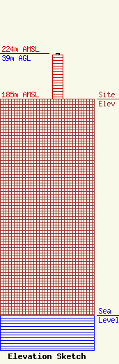
Site Elevation: 185 meters (607 ft) |
| Height of Structure: 38 meters (125 feet) |
| Overall Height Above Ground: 39 meters (128 feet) |
| Overall Height Above Mean Sea Level: 224 meters (735 feet) |
| Owner Info | Sinclair Media III, Inc.
10706 Beaver Dam Road
Cockeysville, MD 21030
(410) 568-1500
|
