|
|
Antenna Structure Registration 1035334 |
 |
Registration Info | Registration Number: 1035334 |
| File Number: A0921604 |
| FAA Study: 97-ASO-3188-OE |
| FAA Issue Date: 10/01/1997 |
| Status: Constructed |
| Date Constructed: 08/13/2013 |
| FAA EMI: N |
| NEPA: N |
Structure Info
| Structure Type: LTOWER |
| Structure Coordinates: 27-25-17.0 N 80-21-24.0 W (NAD 83) |
| Structure Coordinates: 27-25-15.9 N 80-21-24.8 W (Converted to NAD 27) |
| Structure Address: 3209 Virginia Avenue |
| Structure City: Ft. Pierce, FL |
| Structure County: St. Lucie County |
| Painting & Lighting Info |
FAA Circular #: 70/7460-1J |
FAA Chapters: 4, 5, 6, 8, 13 |
| Elevation Info |
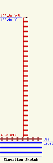
Site Elevation: 4.9 meters (16 ft) |
| Height of Structure: 152.4 meters (500 feet) |
| Overall Height Above Ground: 152.4 meters (500 feet) |
| Overall Height Above Mean Sea Level: 157.3 meters (516 feet) |
| Owner Info | INDIAN RIVER STATE COLLEGE
3209 VIRGINIA AVENUE
FT. PIERCE, FL 34981
(772) 462-4700
rmurdock@irsc.edu |
| Contact Info | Indian River Community College
3209 Virginia Avenue
Fort Pierce, FL 34981-5541
(772) 462-4700
rmurdock@irsc.edu |
