|
|
Antenna Structure Registration 1035353 |
 |
Registration Info | Registration Number: 1035353 |
| File Number: A1139017 |
| FAA Study: 2018-ANE-709-OE |
| FAA Issue Date: 02/15/2018 |
| Status: Constructed |
| Date Constructed: 02/21/2018 |
| NEPA: N |
Structure Info
| Structure Type: GTOWER |
| Structure Coordinates: 44-9-15.0 N 70-0-35.0 W (NAD 83) |
| Structure Coordinates: 44-09-14.7 N 70-00-36.8 W (Converted to NAD 27) |
| Structure Address: Oak Hill Road |
| Structure City: Litchfield, ME |
| Structure County: Kennebec County |
| Painting & Lighting Info |
FAA Circular #: 70/7460-1L |
FAA Chapters: 3, 4, 5, 12 |
Remarks: PRIOR STUDY 1997-ANE-364-OE |
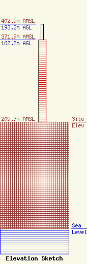
| Elevation Info |
Site Elevation: 209.7 meters (688 ft) |
| Height of Structure: 162.2 meters (532 feet) |
| Overall Height Above Ground: 193.2 meters (634 feet) |
| Overall Height Above Mean Sea Level: 402.9 meters (1322 feet) |
| Owner Info | Maine Public Broadcasting Corp
1450 Lisbon St.
Lewiston, ME 04240
(207) 404-5118
jmahaney@mainepublic.org |
| Contact Info | Maine Public Broadcasting Corp
63 Texas Ave
Bangor, ME 04401
Jeffrey Mahaney
(207) 404-5118
jmahaney@mainepublic.org |
