|
|
Antenna Structure Registration 1035671 |
 |
Registration Info | Registration Number: 1035671 |
| File Number: A0042134 |
| FAA Study: 79-AEA-894-OE |
| FAA Issue Date: 02/15/1980 |
| Status: Constructed |
| Date Constructed: 01/01/1981 |
| NEPA: N |
Structure Info
| Structure Type: TOWER |
| Structure Coordinates: 39-36-29.0 N 79-59-6.0 W (NAD 83) |
| Structure Coordinates: 39-36-28.7 N 79-59-06.8 W (Converted to NAD 27) |
| Structure Address: E Side Of Old Dupont Rd |
| Structure City: Morgantown, WV |
| Structure County: Monongalia County |
| Painting & Lighting Info |
FCC Paragraph(s): 1, 3, 12, 21 |
Remarks: RED LIGHTS/PAINT |
| Elevation Info |
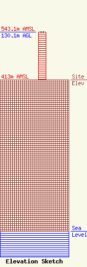
Site Elevation: 413 meters (1355 ft) |
| Height of Structure: 130.1 meters (427 feet) |
| Overall Height Above Ground: 130.1 meters (427 feet) |
| Overall Height Above Mean Sea Level: 543.1 meters (1782 feet) |
| Owner Info | WEST VIRGINIA RADIO CORPORATION
1251 EARL L CORE RD
MORGANTOWN, WV 26505
(304) 296-0029
WVAQ@WVAQ.COM |
