|
|
Antenna Structure Registration 1035680 |
 |
Registration Info | Registration Number: 1035680 |
| File Number: A1382070 |
| FAA Study: 2025-AEA-14903-OE |
| FAA Issue Date: 04/03/2026 |
| Status: Constructed |
| Date Constructed: 10/06/1989 |
| NEPA: N |
Structure Info
| Structure Type: LTOWER |
| Structure Coordinates: 39-8-16.5 N 77-49-57.6 W (NAD 83) |
| Structure Coordinates: 39-08-16.1 N 77-49-58.6 W (Converted to NAD 27) |
| Structure Address: 17430 Poppy Road (092816) |
| Structure City: Charles Town, WV |
| Structure County: Jefferson County |
| Painting & Lighting Info |
FAA Circular #: 70/7460-1K |
FAA Chapters: 4, 8, 12 |
Remarks: OM&L to remain the same as prior study = A MED-DUAL SYSTEM |
Remarks: PRIOR STUDY 2014-AEA-4479-OE |
Remarks: OM&L to remain the same as prior study = A MED-DUAL SYSTEM |
Remarks: PRIOR STUDY 2014-AEA-4479-OE |
| Elevation Info |
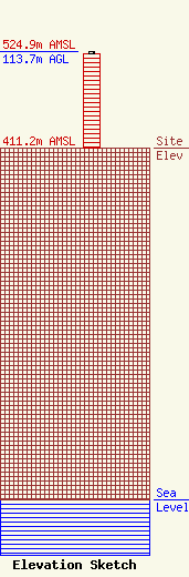
Site Elevation: 411.2 meters (1349 ft) |
| Height of Structure: 111.3 meters (365 feet) |
| Overall Height Above Ground: 113.7 meters (373 feet) |
| Overall Height Above Mean Sea Level: 524.9 meters (1722 feet) |
| Owner Info | American Towers LLC
10 Presidential Way
Woburn, MA 01801
(781) 926-4500
faa-fcc@americantower.com |
| Contact Info | American Towers LLC
10 Presidential Way
Woburn, MA 01801
(781) 926-4500
faa-fcc@americantower.com |
