|
|
Antenna Structure Registration 1035938 |
 |
Registration Info | Registration Number: 1035938 |
| File Number: A0042454 |
| FAA Study: 92-AGL-1683-OE |
| FAA Issue Date: 09/21/1992 |
| Status: Constructed |
| Date Constructed: 09/01/1993 |
| NEPA: N |
Structure Info
| Structure Type: TOWER |
| Structure Coordinates: 44-9-30.0 N 88-17-3.0 W (NAD 83) |
| Structure Coordinates: 44-09-30.0 N 88-17-02.6 W (Converted to NAD 27) |
| Structure Address: N7371 High Cliff Rd |
| Structure City: Sherwood, WI |
| Structure County: Calumet County |
| Painting & Lighting Info |
FAA Circular #: 70/7460-1H |
FAA Chapters: 4, 6, 13 |
| Elevation Info |
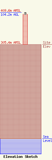
Site Elevation: 305.4 meters (1002 ft) |
| Height of Structure: 98.5 meters (323 feet) |
| Overall Height Above Ground: 104.2 meters (342 feet) |
| Overall Height Above Mean Sea Level: 409.6 meters (1344 feet) |
| Owner Info | MILWAUKEE REPEATER SERVICE INC
2701 S 92ND AT
WEST ALLIS, WI 53227
(414) 541-2900
|
