|
|
Antenna Structure Registration 1036633 |
 |
Registration Info | Registration Number: 1036633 |
| File Number: A1341960 |
| FAA Study: 2022-ASO-5141-OE |
| FAA Issue Date: 06/28/2022 |
| Status: Granted |
| Date Constructed: 11/01/1986 |
| NEPA: N |
Structure Info
| Structure Type: GTOWER |
| Structure Coordinates: 34-49-6.0 N 86-44-17.2 W (NAD 83) |
| Structure Coordinates: 34-49-05.7 N 86-44-17.2 W (Converted to NAD 27) |
| Structure Address: Top Of Capshaw Mtn Off Wall-triana Rd (us-al-5156) |
| Structure City: Madison, AL |
| Structure County: Madison County |
| Painting & Lighting Info |
FAA Circular #: 70/7460-1M |
FAA Chapters: 4, 8, 15 |
Remarks: PRIOR STUDY 1984-ASO-94-OE |
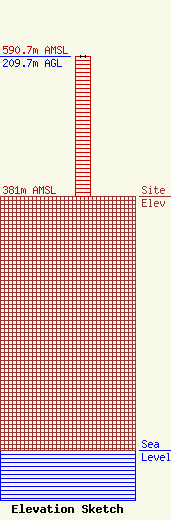
| Elevation Info |
Site Elevation: 381 meters (1250 ft) |
| Height of Structure: 208.7 meters (685 feet) |
| Overall Height Above Ground: 209.7 meters (688 feet) |
| Overall Height Above Mean Sea Level: 590.7 meters (1938 feet) |
| Owner Info | VB Nimbus, LLC
22 W Atlantic Avenue
Delray Beach, FL 33444
(561) 406-4015
fcc-faa@verticalbridge.com |
| Contact Info | VB Nimbus, LLC
22 W Atlantic Avenue
Delray Beach, FL 33444
Richard Hickey
(561) 406-4015
fcc-faa@verticalbridge.com |
