|
|
Antenna Structure Registration 1036781 |
 |
Registration Info | Registration Number: 1036781 |
| File Number: A1344461 |
| FAA Study: 97-ASO-5146-OE |
| FAA Issue Date: 11/26/1997 |
| Status: Constructed |
| Date Constructed: 04/18/1997 |
| FAA EMI: Y |
| NEPA: N |
Structure Info
| Structure Type: TOWER |
| Structure Coordinates: 38-2-6.0 N 84-27-2.0 W (NAD 83) |
| Structure Coordinates: 38-02-05.7 N 84-27-02.2 W (Converted to NAD 27) |
| Structure Address: 1087 New Circle Road |
| Structure City: Lexington, KY |
| Structure County: Fayette County |
| Painting & Lighting Info |
FAA Circular #: 70/7460-1J |
FAA Chapters: 3, 4, 5, 13 |
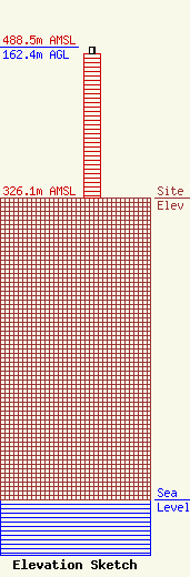
| Elevation Info |
Site Elevation: 326.1 meters (1070 ft) |
| Height of Structure: 156.1 meters (512 feet) |
| Overall Height Above Ground: 162.4 meters (533 feet) |
| Overall Height Above Mean Sea Level: 488.5 meters (1603 feet) |
| Owner Info | Vertical Bridge CC FM, LLC
22 W Atlantic Avenue
Delray Beach, FL 33444
(561) 406-4015
fcc-faa@verticalbridge.com |
| Contact Info | Vertical Bridge CC FM, LLC
22 W Atlantic Avenue
Delray Beach, FL 33444
Richard Hickey
(561) 406-4015
fcc-faa@verticalbridge.com |
