|
|
Antenna Structure Registration 1037465 |
 |
Registration Info | Registration Number: 1037465 |
| File Number: A0044161 |
| FAA Study: 97-ASW-2384-OE |
| FAA Issue Date: 09/05/1997 |
| Status: Terminated |
| Date Constructed: 05/01/1996 |
| NEPA: N |
Structure Info
| Structure Type: POLE |
| Structure Coordinates: 34-50-18.0 N 92-26-56.0 W (NAD 83) |
| Structure Coordinates: 34-50-17.7 N 92-26-55.4 W (Converted to NAD 27) |
| Structure Address: 9721 Pinnacle Valley Road |
| Structure City: Little Rock, AR |
| Structure County: Pulaski County |
| Painting & Lighting Info |
Remarks: SUPERSEDES STUDY #95-ASW-1548-03 |
| Elevation Info |
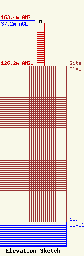
Site Elevation: 126.2 meters (414 ft) |
| Height of Structure: 35.4 meters (116 feet) |
| Overall Height Above Ground: 37.2 meters (122 feet) |
| Overall Height Above Mean Sea Level: 163.4 meters (536 feet) |
| Owner Info | SOUTHWESTERN BELL WIRELESS, INC.
17330 PRESTON ROAD, SUITE 100A
DALLAS, TX 75252
(972) 733-7028
|
