|
|
Antenna Structure Registration 1037667 |
 |
Registration Info | Registration Number: 1037667 |
| File Number: A0904318 |
| FAA Study: 84-ASW-0592-OE |
| Status: Constructed |
| Date Constructed: 01/01/1984 |
| FAA EMI: N |
| NEPA: N |
Structure Info
| Structure Type: 2TOWER |
| Structure Coordinates: 36-12-20.0 N 94-6-7.0 W (NAD 83) |
| Structure Coordinates: 36-12-19.7 N 94-06-06.3 W (Converted to NAD 27) |
| Structure Address: .75 Mi E Of Dodd Ave Hwy 265 |
| Structure City: Springdale, AR |
| Structure County: Washington County |
| Painting & Lighting Info |
FAA Circular #: 70/7460-1F |
FAA Chapters: 3, 4, 5, 9 |
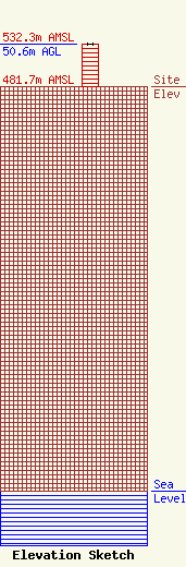
| Elevation Info |
Site Elevation: 481.7 meters (1580 ft) |
| Height of Structure: 50.6 meters (166 feet) |
| Overall Height Above Ground: 50.6 meters (166 feet) |
| Overall Height Above Mean Sea Level: 532.3 meters (1746 feet) |
| Owner Info | Arklahoma Broadcast & Communiaction Towers, LLC
111 Westwood Drive
De Queen, AR 71832
(870) 642-3104
radiotowers@live.com |
| Contact Info | Daniel Communications, LLC
208 Dogwood Drive
Mena, AR 71953
Chris Daniel
(479) 770-3780
radiotowers@live.com |
