|
|
Antenna Structure Registration 1037713 |
 |
Registration Info | Registration Number: 1037713 |
| File Number: A1292684 |
| FAA Study: 98-AEA-3619-OE |
| FAA Issue Date: 02/11/1999 |
| Status: Constructed |
| Date Constructed: 11/15/1998 |
| FAA EMI: N |
| NEPA: N |
Structure Info
| Structure Type: TOWER |
| Structure Coordinates: 39-36-18.0 N 77-46-48.0 W (NAD 83) |
| Structure Coordinates: 39-36-17.7 N 77-46-49.0 W (Converted to NAD 27) |
| Structure Address: End Of Tower Drive |
| Structure City: Williamsport, MD |
| Structure County: Washington County |
| Painting & Lighting Info |
FAA Circular #: 70/7460-1J |
FAA Chapters: 3, 4, 5, 13 |
Remarks: Removed expiration date from determination. Scenario 1./jjs/case#635066 |
| Elevation Info |
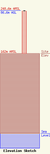
Site Elevation: 162 meters (531 ft) |
| Height of Structure: 85.6 meters (281 feet) |
| Overall Height Above Ground: 86.6 meters (284 feet) |
| Overall Height Above Mean Sea Level: 248.6 meters (816 feet) |
| Owner Info | West Virginia Radio Corporation
1251 Earl L Core Rd
Morgantown, WV 26505
(304) 292-2222
ken@wvradio.com |
| Contact Info | West Virginia Radio Corporation
1251 Earl L Core Rd
Morgantown, WV 26505
Kenneth Tennant
(304) 292-2222
ken@wvradio.com |
