|
|
Antenna Structure Registration 1037798 |
 |
Registration Info | Registration Number: 1037798 |
| File Number: A1207701 |
| FAA Study: 97-ACE-1571-OE |
| FAA Issue Date: 12/17/1997 |
| Status: Constructed |
| Date Constructed: 05/01/1953 |
| NEPA: N |
Structure Info
| Structure Type: GTOWER |
| Structure Coordinates: 38-3-21.4 N 97-46-36.1 W (NAD 83) |
| Structure Coordinates: 38-03-21.4 N 97-46-34.9 W (Converted to NAD 27) |
| Structure Address: East 4th Street And Buhler Road; 8.2 Miles East Of |
| Structure City: Hutchinson, KS |
| Structure County: Reno County |
| Painting & Lighting Info |
FAA Circular #: 70/7460-1J |
FAA Chapters: 3, 4, 5, 13 |
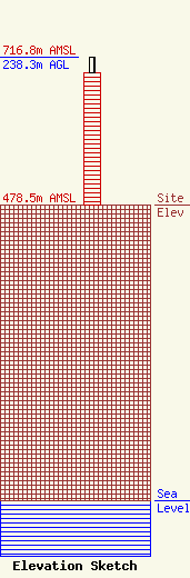
| Elevation Info |
Site Elevation: 478.5 meters (1570 ft) |
| Height of Structure: 214.1 meters (702 feet) |
| Overall Height Above Ground: 238.3 meters (782 feet) |
| Overall Height Above Mean Sea Level: 716.8 meters (2352 feet) |
| Owner Info | Kansas Public Telecommunications Service, Inc.
320 W. 21st Street N.
Wichita, KS 67203
(316) 838-3090
dmcclintock@kpts.org |
| Contact Info | Kansas Public Telecommunications Service, Inc.
320 W. 21st Street N.
Wichita, KS 67203
(316) 838-3090
dmcclintock@kpts.org |
