|
|
Antenna Structure Registration 1037922 |
 |
Registration Info | Registration Number: 1037922 |
| File Number: A0838344 |
| FAA Study: 87-ASW-0486-OE |
| FAA Issue Date: 06/24/1987 |
| Status: Constructed |
| Date Constructed: 01/01/1988 |
| FAA EMI: N |
| NEPA: N |
Structure Info
| Structure Type: TOWER |
| Structure Coordinates: 34-47-33.0 N 92-28-43.0 W (NAD 83) |
| Structure Coordinates: 34-47-32.7 N 92-28-42.4 W (Converted to NAD 27) |
| Structure Address: Atop Crystal Mountain 12 Km W |
| Structure City: Little Rock, AR |
| Structure County: Pulaski County |
| Painting & Lighting Info |
FCC Paragraph(s): 1, 3, 4, 13, 21 |
Remarks: RED LIGHTS/PAINT |
| Elevation Info |
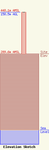
Site Elevation: 289.6 meters (950 ft) |
| Height of Structure: 158.5 meters (520 feet) |
| Overall Height Above Ground: 158.5 meters (520 feet) |
| Overall Height Above Mean Sea Level: 448.1 meters (1470 feet) |
| Owner Info | C & W Communications
2500
Hot Springs, AR 71913
Steve Gill
(501) 609-0900
sgill@wletc.com |
| Contact Info | Mid South Communications
2500
Hot Springs, AR 71914
Steve Gill
(501) 609-0900
sgill@wletc.com |
