|
|
Antenna Structure Registration 1037968 |
 |
Registration Info | Registration Number: 1037968 |
| File Number: A1133324 |
| FAA Study: 2017-AGL-9824-OE |
| FAA Issue Date: 06/27/2017 |
| Status: Constructed |
| Date Constructed: 03/27/2019 |
| NEPA: N |
Structure Info
| Structure Type: GTOWER |
| Structure Coordinates: 48-3-2.2 N 101-23-26.7 W (NAD 83) |
| Structure Coordinates: 48-03-02.2 N 101-23-25.1 W (Converted to NAD 27) |
| Structure Address: 6601 177th Avenue Sw |
| Structure City: Minot, ND |
| Structure County: Ward County |
| Painting & Lighting Info |
FAA Circular #: 70/7460-1L |
FAA Chapters: 3, 4, 5, 12 |
Remarks: PRIOR STUDY 2003-AGL-640-OE |
Remarks: Removed expiration date from determination. Scenario 1./jjs/case#635066 |
Remarks: PRIOR STUDY 2003-AGL-640-OE |
Remarks: Removed expiration date from determination. Scenario 1./jjs/case#635066 |
| Elevation Info |
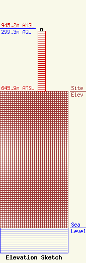
Site Elevation: 645.9 meters (2119 ft) |
| Height of Structure: 287.7 meters (944 feet) |
| Overall Height Above Ground: 299.3 meters (982 feet) |
| Overall Height Above Mean Sea Level: 945.2 meters (3101 feet) |
| Owner Info | PRAIRIE PUBLIC BROADCASTING INC
207 North 5th Street
FARGO, ND 58108-3240
(701) 241-6900
janderson@prairiepublic.org |
| Contact Info | PRAIRIE PUBLIC BROADCASTING INC
207 North 5th Street
FARGO, ND 58108-3240
Jack Anderson
(701) 241-6900
janderson@prairiepublic.org |
