|
|
Antenna Structure Registration 1037970 |
 |
Registration Info | Registration Number: 1037970 |
| File Number: A0685433 |
| FAA Study: 2009-AGL-3955-OE |
| FAA Issue Date: 05/13/2010 |
| Status: Constructed |
| Date Constructed: 07/21/2009 |
| FAA EMI: N |
| NEPA: N |
Structure Info
| Structure Type: TOWER |
| Structure Coordinates: 46-43-35.0 N 102-54-59.0 W (NAD 83) |
| Structure Coordinates: 46-43-35.0 N 102-54-57.4 W (Converted to NAD 27) |
| Structure Address: 16.9 Km S 937 Km W |
| Structure City: Dickinson, ND |
| Structure County: Stark County |
| Painting & Lighting Info |
FCC Paragraph(s): 1, 3, 4, 13, 21 |
Remarks: Continue As Is OM&L = PAINT/RED LIGHTS |
| Elevation Info |
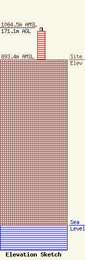
Site Elevation: 893.4 meters (2931 ft) |
| Height of Structure: 152.4 meters (500 feet) |
| Overall Height Above Ground: 171.1 meters (561 feet) |
| Overall Height Above Mean Sea Level: 1064.5 meters (3492 feet) |
| Owner Info | PRAIRIE PUBLIC BROADCASTING INC
3240
FARGO, ND 58108-3240
(701) 241-6900
JACKANDERSON@POL.ORG |
