|
|
Antenna Structure Registration 1038022 |
 |
Registration Info | Registration Number: 1038022 |
| File Number: A1335330 |
| FAA Study: 2025-AGL-6360-OE |
| FAA Issue Date: 05/13/2025 |
| Status: Granted |
| Date Constructed: 12/20/1991 |
| NEPA: N |
Structure Info
| Structure Type: GTOWER |
| Structure Coordinates: 46-17-55.4 N 98-51-57.7 W (NAD 83) |
| Structure Coordinates: 46-17-55.5 N 98-51-56.3 W (Converted to NAD 27) |
| Structure Address: 6.4km East Of Kulm |
| Structure City: Kulm, ND |
| Structure County: LaMoure County |
| Painting & Lighting Info |
FAA Circular #: 70/7460-1M |
FAA Chapters: 4, 8, 15 |
Remarks: PRIOR STUDY 2024-AGL-9744-OE |
Remarks: OM&L to remain the same as prior study = A MED-DUAL SYSTEM |
Remarks: PRIOR STUDY 2024-AGL-9744-OE |
Remarks: OM&L to remain the same as prior study = A MED-DUAL SYSTEM |
| Elevation Info |
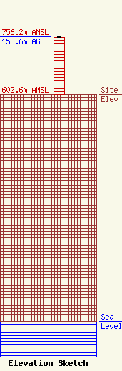
Site Elevation: 602.6 meters (1977 ft) |
| Height of Structure: 152.4 meters (500 feet) |
| Overall Height Above Ground: 153.6 meters (504 feet) |
| Overall Height Above Mean Sea Level: 756.2 meters (2481 feet) |
| Owner Info | Prairie Public Broadcasting, Inc.
207 North 5th Street
3240
Fargo, ND 58108
(701) 241-6900
janderson@prairiepublic.org |
| Contact Info | Prairie Public Broadcasting, Inc.
207 North 5th Street
3240
Fargo, ND 58108
Jack Anderson
(701) 239-7504
janderson@prairiepublic.org |
