|
|
Antenna Structure Registration 1038531 |
 |
Registration Info | Registration Number: 1038531 |
| File Number: A0045395 |
| Status: Constructed |
| Date Constructed: 01/01/1994 |
| NEPA: N |
Structure Info
| Structure Type: B |
| Structure Coordinates: 39-54-45.0 N 74-58-31.0 W (NAD 83) |
| Structure Coordinates: 39-54-44.6 N 74-58-32.4 W (Converted to NAD 27) |
| Structure Address: Between Rt 295 & Rt 70 |
| Structure City: Cherry Hill, NJ |
| Structure County: Camden County |
| Painting & Lighting Info |
FCC Paragraph(s): None |
| Elevation Info |
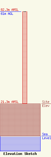
Site Elevation: 21.3 meters (70 ft) |
| Height of Structure: 61 meters (200 feet) |
| Overall Height Above Ground: 61 meters (200 feet) |
| Overall Height Above Mean Sea Level: 82.3 meters (270 feet) |
| Owner Info | LANDMARK APARTMENTS
6845 WESTFIELD AVE
PENNSAUKEN, NJ 08110
(609) 317-1795
TEKTRON_1@AOL.COM |
