|
|
Antenna Structure Registration 1039904 |
 |
Registration Info | Registration Number: 1039904 |
| File Number: A1256242 |
| FAA Study: 2022-ASO-20922-OE |
| FAA Issue Date: 03/09/2023 |
| Status: Constructed |
| Date Constructed: 12/01/1991 |
| NEPA: N |
Structure Info
| Structure Type: LTOWER |
| Structure Coordinates: 31-33-25.0 N 91-23-0.0 W (NAD 83) |
| Structure Coordinates: 31-33-24.4 N 91-22-59.6 W (Converted to NAD 27) |
| Structure Address: 0.2 Km Northeast Of Liberty Road & Devereaux Road (#206567) |
| Structure City: Natchez, MS |
| Structure County: Adams County |
| Painting & Lighting Info |
FAA Circular #: 70/7460-1M |
FAA Chapters: 4, 8, 15 |
Remarks: PRIOR STUDY 1991-ASO-1508-OE |
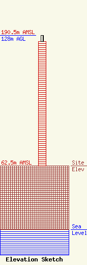
| Elevation Info |
Site Elevation: 62.5 meters (205 ft) |
| Height of Structure: 121.9 meters (400 feet) |
| Overall Height Above Ground: 128 meters (420 feet) |
| Overall Height Above Mean Sea Level: 190.5 meters (625 feet) |
| Owner Info | American Towers LLC
10 Presidential Way
Woburn, MA 01801
(781) 926-4500
faa-fcc@americantower.com |
| Contact Info | American Towers LLC
10 Presidential Way
Woburn, MA 01801
(781) 926-4500
faa-fcc@americantower.com |
