|
|
Antenna Structure Registration 1040183 |
 |
Registration Info | Registration Number: 1040183 |
| File Number: A1381634 |
| FAA Study: 2013-ASO-6030-OE |
| FAA Issue Date: 07/23/2013 |
| Status: Constructed |
| Date Constructed: 08/06/2013 |
| FAA EMI: N |
| NEPA: N |
Structure Info
| Structure Type: GTOWER |
| Structure Coordinates: 33-47-40.0 N 89-5-16.0 W (NAD 83) |
| Structure Coordinates: 33-47-39.6 N 89-05-15.8 W (Converted to NAD 27) |
| Structure Address: On Fire Tower Road, 2.1 Miles Nw |
| Structure City: Woodland, MS |
| Structure County: Chickasaw County |
| Painting & Lighting Info |
FAA Chapters: 3, 4, 5, 12 |
Remarks: PRIOR STUDY 2008-ASO-2105-OE CHAPTERS 3,4,5,12 (1K) ADD SPECIAL CONDTION FOR LIGHTING DEVIATION |
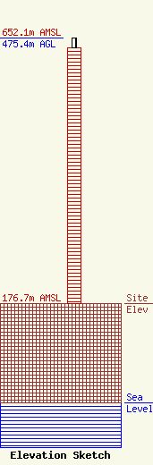
| Elevation Info |
Site Elevation: 176.7 meters (580 ft) |
| Height of Structure: 457.8 meters (1502 feet) |
| Overall Height Above Ground: 475.4 meters (1560 feet) |
| Overall Height Above Mean Sea Level: 652.1 meters (2139 feet) |
| Owner Info | Gray Local Media, Inc.
4370 Peachtree Road, NE
Atlanta, GA 30319
(404) 504-9828
rob.folliard@graymedia.com |
| Contact Info | Cooley LLP
1299 Pennsylvania Avenue, NW
Washington, DC 20004
Henry Wendel
(202) 776-2943
hwendel@cooley.com |
