|
|
Antenna Structure Registration 1040517 |
 |
Registration Info | Registration Number: 1040517 |
| File Number: A1381182 |
| FAA Study: 2024-AGL-14152-OE |
| FAA Issue Date: 11/13/2024 |
| Status: Constructed |
| Date Constructed: 11/14/2024 |
| NEPA: N |
Structure Info
| Structure Type: LTOWER |
| Structure Coordinates: 39-58-13.0 N 83-1-27.0 W (NAD 83) |
| Structure Coordinates: 39-58-12.8 N 83-01-27.3 W (Converted to NAD 27) |
| Structure Address: 770 Twin Rivers Drive |
| Structure City: Columbus, OH |
| Structure County: Franklin County |
| Painting & Lighting Info |
FAA Circular #: 70/7460-1M |
FAA Chapters: 4, 9, 15 |
Remarks: PRIOR STUDY 1981-AGL-33-OE |
| Elevation Info |
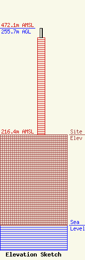
Site Elevation: 216.4 meters (710 ft) |
| Height of Structure: 232.9 meters (764 feet) |
| Overall Height Above Ground: 255.7 meters (839 feet) |
| Overall Height Above Mean Sea Level: 472.1 meters (1549 feet) |
| Owner Info | WBNS-TV, Inc.
8401 Greensboro Drive
McLean, VA 22102
(703) 873-6600
lawdept@tegna.com |
| Contact Info | TEGNA Inc.
8401 Greensboro Drive
McLean, VA 22102
Denise Branson
(703) 873-6606
dbranson@tegna.com |
