|
|
Antenna Structure Registration 1040555 |
 |
Registration Info | Registration Number: 1040555 |
| File Number: A0047764 |
| FAA Study: 87-ASW-1058-OE |
| FAA Issue Date: 07/21/1988 |
| Status: Constructed |
| Date Constructed: 10/28/1988 |
| NEPA: N |
Structure Info
| Structure Type: TOWER |
| Structure Coordinates: 33-38-19.0 N 92-27-39.0 W (NAD 83) |
| Structure Coordinates: 33-38-18.6 N 92-27-38.4 W (Converted to NAD 27) |
| Structure Address: .4 Mi E Of Hwy 167 7 Mi N |
| Structure City: Hampton, AR |
| Structure County: Calhoun County |
| Painting & Lighting Info |
FCC Paragraph(s): 1, 3, 11, 21 |
Remarks: RED LIGHTS/PAINT |
| Elevation Info |
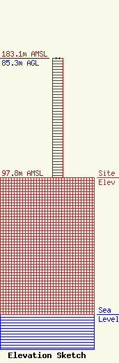
Site Elevation: 97.8 meters (321 ft) |
| Height of Structure: 85.3 meters (280 feet) |
| Overall Height Above Ground: 85.3 meters (280 feet) |
| Overall Height Above Mean Sea Level: 183.1 meters (601 feet) |
| Owner Info | ARKANSAS, STATE OF
1 STATE POLICE PLZ DR
LITTLE ROCK, AR 72209
(501) 618-8700
|
