|
|
Antenna Structure Registration 1040615 |
 |
Registration Info | Registration Number: 1040615 |
| File Number: A0047834 |
| FAA Study: 87-ASW-1868-OE |
| FAA Issue Date: 12/08/1987 |
| Status: Constructed |
| Date Constructed: 01/13/1989 |
| NEPA: N |
Structure Info
| Structure Type: TOWER |
| Structure Coordinates: 33-53-50.0 N 92-33-1.0 W (NAD 83) |
| Structure Coordinates: 33-53-49.6 N 92-33-00.4 W (Converted to NAD 27) |
| Structure Address: 11 Mi Nnw Of Fordyce .9 Mi Ne Of Hwy 80 |
| Structure City: Ramsey, AR |
| Structure County: Dallas County |
| Painting & Lighting Info |
FCC Paragraph(s): 1, 3, 11, 21 |
Remarks: RED LIGHTS/PAINT |
| Elevation Info |
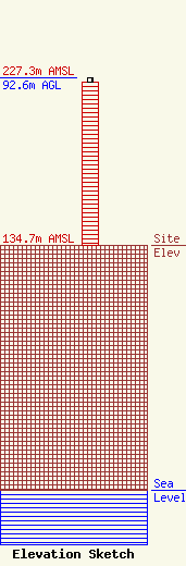
Site Elevation: 134.7 meters (442 ft) |
| Height of Structure: 89.9 meters (295 feet) |
| Overall Height Above Ground: 92.6 meters (304 feet) |
| Overall Height Above Mean Sea Level: 227.3 meters (746 feet) |
| Owner Info | ARKANSAS, STATE OF
1 STATE POLICE PLAZA DR
LITTLE ROCK, AR 72209
(501) 618-8700
|
