|
|
Antenna Structure Registration 1040629 |
 |
Registration Info | Registration Number: 1040629 |
| File Number: A0910445 |
| FAA Study: 2007-ASW-4485-OE |
| FAA Issue Date: 06/28/2007 |
| Status: Constructed |
| Date Constructed: 02/04/2008 |
| FAA EMI: N |
| NEPA: N |
Structure Info
| Structure Type: TOWER |
| Structure Coordinates: 33-17-59.3 N 93-14-0.4 W (NAD 83) |
| Structure Coordinates: 33-17-58.8 N 93-13-59.8 W (Converted to NAD 27) |
| Structure Address: 0050 Old Mc Neil Hwy |
| Structure City: Magnolia, AR |
| Structure County: Columbia County |
| Painting & Lighting Info |
FCC Paragraph(s): 1, 3, 12, 21 |
Remarks: PRIOR STUDY 1998-ASW-190-OE |
Remarks: Continue As Is OM&L = PAINT/RED LIGHTS |
Remarks: PRIOR STUDY 1998-ASW-190-OE |
Remarks: Continue As Is OM&L = PAINT/RED LIGHTS |
| Elevation Info |
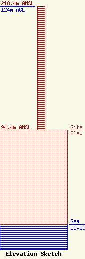
Site Elevation: 94.4 meters (310 ft) |
| Height of Structure: 124 meters (407 feet) |
| Overall Height Above Ground: 124 meters (407 feet) |
| Overall Height Above Mean Sea Level: 218.4 meters (717 feet) |
| Owner Info | Noalmark Broadcasting Corporation
202 West 19th Street
El Dorado, AR 71730
(870) 862-7777
anna@noalmark.com |
| Contact Info | Noalmark Broadcasting Corporation
202 West 19th Street
El Dorado, AR 71730
Anna Canterbury
(870) 862-7777
anna@noamark.com |
