|
|
Antenna Structure Registration 1040655 |
 |
Registration Info | Registration Number: 1040655 |
| File Number: A1170125 |
| FAA Study: 92-ASW-1735-OE |
| FAA Issue Date: 12/01/1992 |
| Status: Dismantled |
| Date Constructed: 01/01/1992 |
| FAA EMI: N |
| NEPA: N |
Structure Info
|
| Structure Coordinates: 34-47-56.0 N 92-29-54.0 W (NAD 83) |
| Structure Coordinates: 34-47-55.7 N 92-29-53.4 W (Converted to NAD 27) |
| Structure Address: Shinall Mountain Antenna Farm W |
| Structure City: Little Rock, AR |
| Structure County: Pulaski County |
| Painting & Lighting Info |
FAA Chapters: NONE |
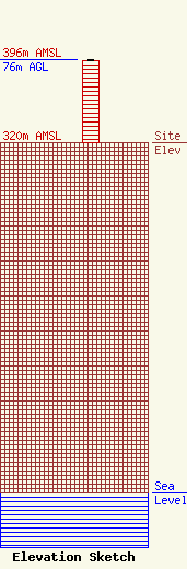
| Elevation Info |
Site Elevation: 320 meters (1050 ft) |
| Height of Structure: 75 meters (246 feet) |
| Overall Height Above Ground: 76 meters (249 feet) |
| Overall Height Above Mean Sea Level: 396 meters (1299 feet) |
| Owner Info | Signal Media of Arkansas, Inc.
2400 Cottondale Lane
Little Rock, AR 72202
(501) 664-9410
steve@signalmedia.com |
| Contact Info | Duane Morris LLP
505 9th Street, NW, Suite 1000
Washington, DC 20004-2166
William Keane
(202) 776-5243
kkeane@duanemorris.com |
