|
|
Antenna Structure Registration 1040671 |
 |
Registration Info | Registration Number: 1040671 |
| File Number: A1381771 |
| FAA Study: 2026-AGL-4963-OE |
| FAA Issue Date: 04/06/2026 |
| Status: Constructed |
| Date Constructed: 01/01/1987 |
| NEPA: N |
Structure Info
| Structure Type: GTOWER |
| Structure Coordinates: 40-25-26.0 N 88-52-27.0 W (NAD 83) |
| Structure Coordinates: 40-25-25.9 N 88-52-26.7 W (Converted to NAD 27) |
| Structure Address: One Mile North Of City Il-5689 |
| Structure City: Downs, IL |
| Structure County: McLean County |
| Painting & Lighting Info |
FAA Circular #: 70/7460-1M |
FAA Chapters: 4, 8, 15 |
Remarks: PRIOR STUDY 2008-AGL-6310-OE |
| Elevation Info |
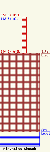
Site Elevation: 240.8 meters (790 ft) |
| Height of Structure: 111.9 meters (367 feet) |
| Overall Height Above Ground: 112.8 meters (370 feet) |
| Overall Height Above Mean Sea Level: 353.6 meters (1160 feet) |
| Owner Info | VB Nimbus, LLC
22 W Atlantic Avenue
Delray Beach, FL 33444
(561) 406-4015
fcc-faa@verticalbridge.com |
| Contact Info | VB Nimbus, LLC
22 W Atlantic Avenue
Delray Beach, FL 33444
Richard Hickey
(561) 406-4015
fcc-faa@verticalbridge.com |
