|
|
Antenna Structure Registration 1040887 |
 |
Registration Info | Registration Number: 1040887 |
| File Number: A0626169 |
| FAA Study: 68-MKC-509-OE |
| FAA Issue Date: 11/07/1968 |
| Status: Constructed |
| Date Constructed: 05/16/1969 |
| FAA EMI: N |
| NEPA: N |
Structure Info
| Structure Type: TOWER |
| Structure Coordinates: 37-4-10.0 N 94-32-50.0 W (NAD 83) |
| Structure Coordinates: 37-04-09.8 N 94-32-49.2 W (Converted to NAD 27) |
| Structure Address: 2510 W 20th St |
| Structure City: Joplin, MO |
| Structure County: Jasper County |
| Painting & Lighting Info |
FCC Paragraph(s): 1, 3, 12, 21 |
Remarks: RED LIGHTS/PAINT |
| Elevation Info |
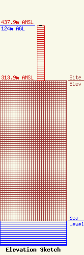
Site Elevation: 313.9 meters (1030 ft) |
| Height of Structure: 123.4 meters (405 feet) |
| Overall Height Above Ground: 124 meters (407 feet) |
| Overall Height Above Mean Sea Level: 437.9 meters (1437 feet) |
| Owner Info | American Media Investments, Inc.
1162 E Highway 126
Pittsburg, KS 66762
(620) 231-7200
|
| Info |
