|
|
Antenna Structure Registration 1040892 |
 |
Registration Info | Registration Number: 1040892 |
| File Number: A1198210 |
| FAA Study: 2021-ANM-3730-OE |
| FAA Issue Date: 06/23/2021 |
| Status: Constructed |
| Date Constructed: 10/26/1997 |
| NEPA: N |
Structure Info
| Structure Type: LTOWER |
| Structure Coordinates: 40-16-43.6 N 111-56-3.3 W (NAD 83) |
| Structure Coordinates: 40-16-43.8 N 111-56-00.5 W (Converted to NAD 27) |
| Structure Address: 11513 West 2616 North (#274056) |
| Structure City: Fairfield, UT |
| Structure County: Utah County |
| Painting & Lighting Info |
FAA Circular #: 70/7460-1M |
FAA Chapters: 4, 8, 15 |
Remarks: PRIOR STUDY 1996-ANM-239-OE |
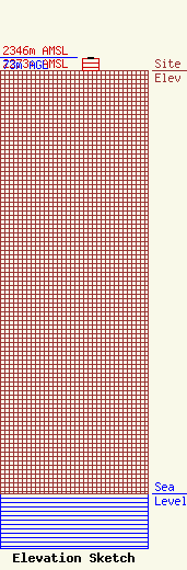
| Elevation Info |
Site Elevation: 2273 meters (7457 ft) |
| Height of Structure: 67 meters (220 feet) |
| Overall Height Above Ground: 73 meters (240 feet) |
| Overall Height Above Mean Sea Level: 2346 meters (7697 feet) |
| Owner Info | American Towers LLC
10 Presidential Way
Woburn, MA 01801
(781) 926-4500
FAA-FCC@americantower.com |
| Contact Info | American Towers LLC
10 Presidential Way
Woburn, MA 01801
(781) 926-4500
FAA-FCC@americantower.com |
