|
|
Antenna Structure Registration 1041009 |
 |
Registration Info | Registration Number: 1041009 |
| File Number: A1194768 |
| FAA Study: 97-AEA-3916-OE |
| Status: Constructed |
| Date Constructed: 01/01/1975 |
| FAA EMI: N |
| NEPA: N |
Structure Info
| Structure Type: 2TOWER |
| Structure Coordinates: 38-30-21.0 N 82-12-33.0 W (NAD 83) |
| Structure Coordinates: 38-30-20.7 N 82-12-33.5 W (Converted to NAD 27) |
| Structure Address: Barkers Ridge Road |
| Structure City: Huntington, WV |
| Structure County: Cabell County |
| Painting & Lighting Info |
FAA Circular #: 70/7460-1J |
FAA Chapters: 4, 9, 13 |
| Elevation Info |
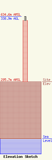
Site Elevation: 295.7 meters (970 ft) |
| Height of Structure: 318 meters (1043 feet) |
| Overall Height Above Ground: 338.9 meters (1112 feet) |
| Overall Height Above Mean Sea Level: 634.6 meters (2082 feet) |
| Owner Info | Nexstar Media Inc.
545 E. John Carpenter Freeway
Irving, TX 75062
(972) 373-8800
jasroberts@nexstar.tv |
| Contact Info | Nexstar Media Inc.
545 E. John Carpenter Freeway
Irving, TX 75062
Jason Roberts
(972) 373-8800
jasroberts@nexstar.tv |
